The Chairman's Trek
A spectacular journey through Nepal and Tibet combining Mount Kailas and the foot of Everest's North East Ridge.
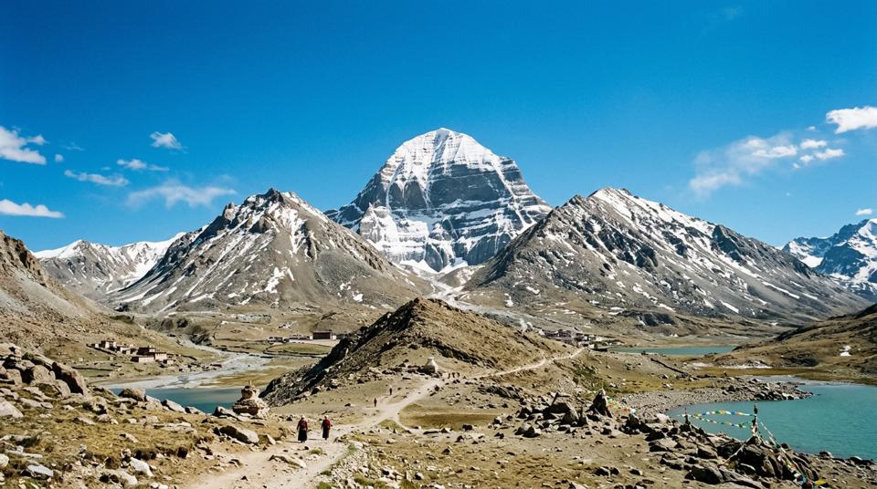
Mount Kailas & the North East Ridge of Everest
Trek from Simikot in Nepal’s western foothills to the fabled Mount Kailas. A spectacular journey across Tibet - the ‘Roof of the World’. Follow in the footsteps of George Mallory up the East Rongbuk Glacier and the ‘Magic Highway’.
Each year a special ‘Chairman’s Trek’ is operated. It offers an ambitious itinerary through Nepal and Tibet which in effect combines two classic treks into one. In a challenging one month programme, visit the mystical Mount Kailas, drive across the high Tibetan plateau to the Rongbuk Monastery and then trek to the foot of the North East Ridge of Everest. Even for the seasoned mountain walker, there can be no doubt that this trek promises to be the trip-of-a-lifetime.
Mount Kailas
Our journey begins in the foothills of western Nepal. We fly from Kathmandu to Simikot and then commence a delightful one week trek which follows the Humla Karnali River north-west towards the Tibetan border. We follow an old trading route used by Tibetans who, many years ago, sold valuable salt to Nepal and returned with grain. Even today remnants of this early commerce still continue and we may see the occasional caravan of yaks plying this trade. After an enjoyable week of walking we reach the border at Taklakot where we are met by our Tibetan colleagues and transferred by jeep to the foot of Mount Kailas. Located north of the main Himalayan chain, Mount Kailas remains one of the World’s most sacred summits. No-one has ever been permitted to climb its virgin slopes and the summit remains untrodden by man. To Buddhists and Hindus alike, it is the most revered peak in the Himalaya. Hindu pilgrims consider the mountain to be the home of their God - Lord Shiva. For Buddhists Mount Kailas is said to be the Centre of the Universe – the Axis Mundi in Asian cosmology. Every year hundreds of pilgrims travel from all over the Indian sub-Continent and Tibet to make the ritual circumambulation around the mountain in their quest for enlightenment and our trek will join them on this journey.
The North East Ridge of Everest
Following our journey across Tibet, we will spend a couple of days resting and acclimatising at the main Rongbuk Base Camp area on the north side of Everest. This will allow us to visit the famous Rongbuk Monastery, now largely restored to its former splendour. The Base Camp area can be reached by four-wheel drive vehicles and so tourist parties sometimes visit in season. We will, however, be travelling into much remoter terrain; after our yaks arrive at Base Camp we commence three days of tough trekking up the East Rongbuk glacier to the foot of Everest’s North East Ridge. The first day is relatively easy, and gives us our first taste of walking on glacial moraine. On the second day we follow the centre of the glacier up Mallory’s ‘Magic Highway’, so named because it provided an easy route through the chaotic and impenetrable ice pinnacles which line both sides of the glacier. This is quite a tough day and we camp on the glacier at an altitude of nearly 6000 metres, with a palpable sense that Everest is very close. On the third day we climb up to an altitude of 6400 metres at Everest’s North Ridge Base Camp. We are rewarded with scenery few trekkers will ever experience. The North Col and North Ridge of Everest rise in a huge sweep above us and we can just make out the Second Step where Noel Odell last saw Mallory and Irvine before the clouds moved in and they became mountaineering folklore. To the south we can gaze up at the tremendous North East Ridge of Everest and the famous pinnacles.
One excursion from Advance Base which should not be missed is a superb glacier hike to the Raphu La, a pass at the foot of the North East Ridge. From this pass we can look towards Makalu and the Tibetan side of Lhotse whilst above us rises the North East Ridge, so close to us that we can actually claim to have stood on Everest! Our time in the mountains finally over, we retrace our steps down the East Rongbuk Glacier covering the distance in one long day, rather than the three it took to ascend. We then return to Kathmandu by road.
The upper reaches of the East Rongbuk glacier have for many decades been the sole preserve of Everest expeditions, inaccessible to all but the most determined. Our trek will be able to venture into this high altitude world of mountains and glaciers for a trekking experience like no other.
Three week option
For those with insufficient time to join the full 31 day departure, there is an option to join the main group at Tingri and then complete the trek up to Everest Advance Base Camp. This itinerary will begin in Kathmandu from where we fly up to Lhasa. We will include visits to the Potala and Jokhang before driving across Tibet through Gyantse and Shigatse to the Crystal Fort at Shegar. We meet up with the rest of the group at Tingri and continue our journey from there.
Itinerary
- DAY 1: We depart from the UK for the overnight flight to Kathmandu. We fly with Qatar Airlines from London Heathrow airport and change planes at Doha in the small Gulf State of Qatar.
- DAY 2: We arrive in Kathmandu in the afternoon and are met by some of our team of Sherpas. We transfer by private coach to the comfortable Hotel Marsyangdi situated in the very centre of the Thamel tourist district of the city. We are within close walking distance of the many restaurants, bars and shops which this part of the city is famous for. After checking into our rooms we can relax in the hotel’s pleasant garden before an early evening meal. Flying to Kathmandu produces considerable jet lag on this first night and most of us will be asleep by 10pm.
- DAY 3: An early start for the domestic flight to the city of Nepalgunj in the far west of Nepal. The flight is extremely scenic as we travel the length of the western Himalaya and we have superb views north to the peaks of Langtang, Manaslu, Annapurna and Dhaulagiri. Situated in the Terrai region on the Indian plains, Nepalgunj can be very hot and we will probably spend most of the day relaxing in the hotel garden.
- DAY 4: We return to the small airport at Nepalgunj and fly by Twin Otter plane up to the village of Simikot (3170m) in Nepal’s far north-western corner. This remote spot is about as far away from Kathmandu as it is possible to get, without actually leaving Nepal. Simikot is the administrative centre of the beautiful Humla district and it is here that we will meet our team of Sherpas and trek crew. After our trek bags have been weighed and divided up between the porters we begin the trek, hiking along the scenic Humla Karnali river to Masigaon (2600m).
- DAY 5: Beyond Simikot the villages are inhabited by an increasing proportion of Bhotias, people of Tibetan extraction. The Humla valley becomes increasingly narrow and the occasional villages which we pass have to make the best use of the limited land available here. Eventually we reach the village of Kermi where Tibetan prayer flags flutter over the houses, whilst the trails are dotted with chortens and mani stones, testament to the rich Buddhist influence.
- DAY 6: From Kermi we climb over a high ridge, reaching an altitude of nearly 3000 metres before descending back down to the Humla river. We cross the Chumsa Khola, a small tributary stream and pass through the pleasant village of Yalbang (2890m). From here we follow an irrigation canal northwards to the neighbouring village of Yangar (2850m) where we camp. There is a small hydroelectric project on the Humla river and these two villages of Yalbang and Yangar both benefit from this. Yangar is an extremely compact village on a steep hillside and in places narrow tunnels have been built beneath the houses.
- DAY 7: We return back to the edge of the river and follow an increasingly precipitous trail, and in places there is nothing more than a narrow wooden walkway propped up with posts. Some sections of the trail have been blasted out of the sheer cliffs. The path wends its way along this rickety trail for a couple of hours until finally we reach a new suspension bridge across the river. We cross this and trek more easily through delightful apricot orchards to the stone houses of Muchu village. Just beyond this lies the police check post which functions as the Nepalese border control. We have our trekking permits and passports checked here, a process which may consume some considerable time. We then continue along the river to Thumkot Khola and with its small village lying just above. Tumkot is also known as Mota Gompa, and the large white gompa is situated on a ridge just beyond the village. We camp here in a pleasant clearing by the fast flowing waters of a mountain stream.
- DAY 8: First thing in the morning we cross the Bumachiya Khola on a small wooden bridge. The Humla Karnali now disappears into a steep cleft to the north, and we leave it behind, heading steeply uphill to the isolated tea house at Palbang (3380m). The local Nepali name for this place is Torea which means mustard, and this yellow-flowering plant grows in abundance in the adjacent fields. The trail then climbs steeply to a ridge where we have great views north to the fields of Yari. This small village is effectively the Nepalese frontier town and there are a variety of offices for police, army and customs as well as a large Gompa. We may stop here for the night but if possible we will continue a little further to the meadows at Sip Sip, a pleasant camp site situated at 4300m at the foot of the Nara Lagna Pass.
- DAY 9: Above Sip Sip we climb steeply up to the Nara Lagna La (4600m). The crest of the pass is marked by a large pile of stones and a colourful collection of prayer flags. The views are superb and we can see some of the remotest of Nepal’s 7000 metre peaks including Api (7132m) and Saipal (7031m) as well as a range of mountains heading west to the border with India. Looking north the landscape is arid and almost totally lacking in vegetation. The irrigated green fields of Sher appear in the distance like an oasis in the otherwise brown desert landscape. We descend down a loose stony path for over 1000 metres and re-join the Humla Karnali which has snaked its way around the mountains. We cross a small bridge over the river and enter Tibet and shortly afterwards arrive at Khojarnath, the first large village in Tibet. The road comes up to here and our Tibetan colleagues meet us with their 4-wheel drive Toyota Land Cruisers. We travel a few miles down the road to Taklakot, known to the Chinese and Tibetans as Purang. Taklakot is a typical Tibetan village – dusty roads and flat-roofed houses. If we arrive in Taklakot early in the day we may continue by road to a campsite by the magical Lake Manasarovar. Otherwise we will stay in Taklakot that night. Despite its drab appearance Taklakot is quite a lively town with a bizarre mixture of Tibetans, Nepalese traders and Chinese army. There are a few restaurants and, curiously, several snooker halls.
- DAY 10: Mount Kailas is much too distant to reach on foot so today we drive to Darchen at the base of the mountain. The drive is about 70 miles and the dirt road passes between the waters of Lake Manasarovar and Rakas Tal.
More pages
- Charity Trek Organise bespoke challenge trips and adventure sports activities to raise funds for your desired organisation.
- The Tour of Mont Blanc The classic high level trek around Europe's highest mountain.